Pinyon Peak

We gave up watching headlights last night. Or most of us did. The opening in Jeremy’s tarp shelter forced him to watch the ridge. He tells us, with a smile, he eventually took a knife to hand.

It was blustering rain, not headlights, though, that disturbed our sleep. Jesse had seepage from below. Joel’s new-ish tent¹ leaked through the fly. And Jeremy didn’t get wet but the flapping tarp kept him awake. Joel’s new Jetboil coffee press is called into action.

We work past the old man morning feeling with caffeine and big beats from Jeremy’s cool speaker. See the smiles?

I noticed my phone yesterday cycling rapidly through charge-discharge notifications while mounted on the dash. And the GPS unit kept locking up. That was frustrating — had to stop and pull the batteries each time. I’m going to dig into the dash and see if I can find the problem.

Jeremy helps me isolate the bad connection to the toggle I’d mounted in the dash. The power post on the back is loose. I remove the switch and push the power ends through the hole in the dash with a twisted off tab of metal to clip and unclip them. That will be the new switch.
I manage to burn out a fuse while playing with things and, having no spare fuses, of course, call upon another twisted bit of metal to bridge the gap. It’s all good now.
This dash, cool as it is, has been the most maintenance intensive part of the bike. It took several rides to iron out rattles with foam and thread lock. And then the whole light mount came loose last time requiring in-field epoxy work.¹

After man and machine maintenance is complete, we enjoy a lazy, hazy morning around the fire — four brothers, highly amusing to ourselves.


We finally load up and head out as the sun begins cutting through the haze. We’re going to check out the lookout before we backtrack a bit and head down the other side of the mountain.

We find we have a strong cellular signal at the lookout so we take a moment to check-in with family and update Facebook.


Morning haze has quickly dissipated leaving us with brilliant views and high spirits.

“I saw someone on a white motorcycle go up on that ridge last night,” says the unsmiling lookout attendant, nodding to the area below.
“That was me,” I confess. “I was looking for a flat place to set our tents.”
“Did you see those headlights around midnight?” Jeremy asks him, describing what we saw. Certainly that was more peculiar. I don’t hear the attendant answer. It makes me wonder if the lights were actually him poking around.
“I have to go record the weather,” he says after we’ve struggled a minute to make small-talk.

The narrow walking path above the trees is lined with diverse flora, orange, pink and purple while forested peaks recede into the surrounding distance, as far as we can see. This breeze, these colors, the encompassing immensity are all the hospitality we need.

We pass a few trucks parked in the middle of the road as we head back down, loaded with maybe ten guys between them. I don’t see smiles here either. “Howdy,” I call as I squeeze by in the ditch. I wonder now if they were the midnight headlights and what they’re after.

Since there was no water where we camped, some borrowing went on to make meals and coffee. We stop at the first trickle we see to replenish our supply.
I almost bought a new filter for this trip but the guy behind the counter at the Benchmark store said “seventy dollars” and that I only needed one after it gets hard to pump. Mine still pumped fine so obviously I wasn’t going to spend $70.
After I fill Jesse’s first two bottles, I notice it’s almost impossible to pump and I remember the salesperson’s words. Last night the Jetboil burner and today my filter — I see how this trip is going.

“That’s bigger than I thought it would be,” my brothers say when we pull in alongside the Deadwood Reservoir dam. Our childhood home in Troy, Idaho, was over the hill from Spring Valley Reservoir which isn’t much more than a large pond. Deadwood is a good sized lake.


Presumably the disintegrating bits of Deadwood Dam are cosmetic, not structural. The old boy is over eighty years old now¹ so I guess some wrinkles are expected.


After a little sightseeing at the reservoir, we navigate by many occupied campsites and up Deadwood River until we see a large open site along the water. That late start out of Boise and today’s morning maintenance has us an hour or two behind the route plan.
“This is a nice spot, plenty of water,” I observe once we’ve all pulled in. “We’re still a few hours away from the planned site. We could stay here instead — have the day to hang out.”
We decide to snack and rest a minute but continue on. Jeremy especially is keen on more riding. That TW must be extra fun.

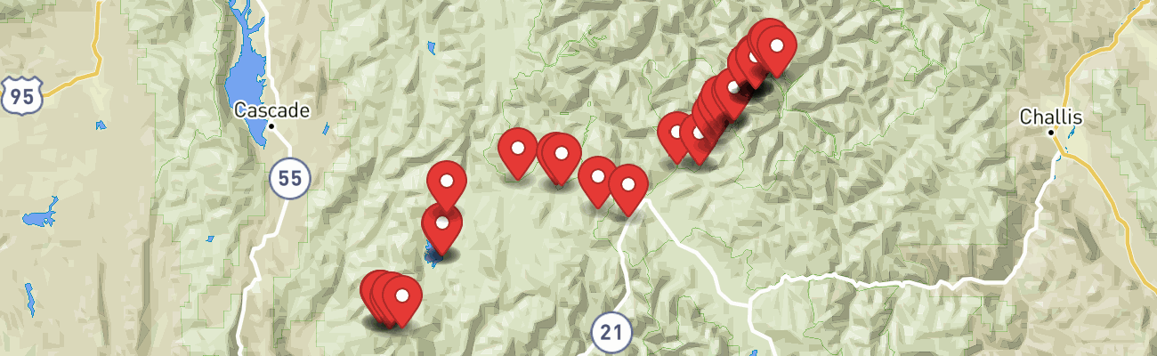
From the Deadwood River we head over Deer Creek Pass to Bear Valley Road where we follow Elk Creek toward Bruce Meadows.

The new trail-made switch is working much better though there’s still an issue with GPS lock-ups. I’ll worry about that another time.

The meadows throughout the Bear Valley area are lush, beautifully adorned with meandering creeks reflecting deep colors, hints of autumn. We glide by these scenes at our bike’s top speeds (which isn’t terribly fast) on straight, empty roads. It’s exhilarating.

The old burn around Cape Horn Summit is always striking — a broad landscape of death with only recent, creeping hints of life.


After a few miles on Highway 21, we turn onto Seafoam Road. My original plan was to camp a night at Seafoam Lake but after seeing pictures of the Halstead fire aftermath,¹ the fire I experienced while camping at Dagger Falls after my first Seafoam attempt,² I had to come up with another plan. The Seafoam basin is completely burned out.

Right instead of left puts us along Beaver Creek toward Pinyon Peak.

Maybe rough for a car but on two wheels this road is like a Star Wars speeder bike scene, spindly trees whizzing by in a blur. What fun!

After waiting several minutes with Joel at a small bridge over Beaver Creek, we decide it’s time to go back and see what’s become of Jeremy and Jesse. I find them a couple miles back. The beloved Fireball whisky and one of Jeremy’s sandals fell somewhere. And now the Husky isn’t starting.
It isn’t clear which issue is worst (the Fireball was fun) but the Husky is mine to figure out while Jeremy searches for the dropped items. Jesse has it pushed off into the grass. The symptoms sound like simple fuel starvation. I wish I knew more about carburetors.
After ruling out easy possibilities — spark plug looks good, gas flows from the petcock, air filter is clean — I decide digging back into the carburetor is all I have left. Maybe something went wrong with that o-ring I installed. I’d better be careful not to drop any little parts here in the grass.

After removing the seat, tank and throttle cables to rotate the carburetor, I’m able to pull the bowl and check the float, valve and needle. Everything looks fine. Which is good and bad — nothing to fix. I make a small tweak to the float valve actuator tab and re-assemble everything.
It fires right up. I’d be glad to take credit but I didn’t really do anything. Oh well, let’s fly while we can!

The Fireball and Jeremy’s sandal were not so fortunate. The mountains claim more of our stuff. They already have our hats, sunglasses and little camera accessories from past years. I guess they wanted more. Greedy bastards.

We pause on the high ridge below Feltham Creek Point. The Husky is doing fine now (best not think too much on that). We are surrounded by stunning views of craggy peaks below bulbous clouds. Wind here blows steadily. We’re bound to find awesome camping now though we wonder what rain may come.


The road since hitting that high ridge has been spectacular, among the best few forest roads I’ve ever ridden, often dropping thousands of feet on both sides toward small lakes and impenetrable saw toothed mountains.


We make the extra climb to the Pinyon Peak Lookout at 9,900 feet. Apparently it’s crabby lookout attendant day because the guy here answers my comment about the wind with a “yep” before shutting his door not to emerge again.


The wind is almost as impressive as the view. We hope our campsite below will be calmer.

We make mental notes of the roads below to help us find our way to an appropriately epic campsite.

Creeks are finding new courses amidst burned out forest floors. It seems both beautiful and tragic. Riding through is kind of surreal.

We pull into the first accessible lake below Pinyon Peak. The space is nice but the water is marshy and we’re hoping to have baths. So we pull out and continue on. The trail the map shows to the last lake, Pinyon, has been erased by the shifting creek and slides. The soil is steep and burned to powder so finding our own path to the lake isn’t practical. Again we continue on.

Jeremy turns to investigate some structures along the road and we follow him in among the trees. Half buried iron shapes across the road, the size of tractors, suggest a substantial mining operation. It’s all obviously long abandoned.

The mine was “named for a packer who, according to local legend, lost his way in the Loon Creek area around 1866 and stumbled across a promising lode of ore.” It “was developed to a depth of 800 feet.” The town of Ivers “was established in 1905 at the mine … A forest fire in August 1931 destroyed the townsite and the entire surface plant of the mine.”¹

I push through some brush to find an old bathtub and makeshift hot tub, now a collapsed wooden octagon, then brap-brap up the bank to the road and lead a short distance to a pull-out along the creek. Maybe this is our campsite. It isn’t epic but it has creek access. And evening is upon us.
“Stay here while I run up the road to see if there’s anything better,” I suggest to the others. “I’ll be back in just a few minutes.” I’m trying to avoid the ironic ride axiom: the best campsite is always a little farther than you were willing to ride.
I tear ahead several miles at full-tilt but find no workable campsites at all. The hard riding sends my Jetboil flying. I was lazy with the last load-in and didn’t roll the dry bag top before clipping it. I skid to a stop and collect the parts. The burner had already failed. Now the cup is an oval.

I can see on my brothers’ faces the site is a letdown but it is what it is. We all know we’ll have a rollicking time no matter what. Before night settles in, I grab my soap and a dry shop rag (towel) and descend fifteen feet to Canyon Creek below our fire. Sitting naked in that high mountain runoff ranks up there with my coldest memories but it sure feels nice to get clean and hustle back fireside. Yeehaw.

Rain comes in bursts. We huddle under pine boughs until it passes then return to our places around the fire. We saw great country and have had a full evening entertaining ourselves so when finally the rain becomes unrelenting we dive into our tents without regret. We just hope it’s gone by morning.
by Jason Abbott