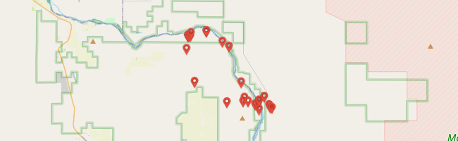
Hunter’s mom graciously suggested he and I might enjoy a motorcycle ride while my niece’s twelfth birthday party was hosted at our house. We didn’t look that gift horse in the mouth. We loaded our bikes and headed across the windy plain to the Snake River. Hunter encouraged me as we drove to hit some of the many tumbleweeds rolling across the highway. I was happy to oblige.

Hunter’s mom graciously suggested he and I might enjoy a motorcycle ride while my niece’s twelfth birthday party was hosted at our house. We didn’t look that gift horse in the mouth. We loaded our bikes and headed across the windy plain to the Snake River. Hunter encouraged me as we drove to hit some of the many tumbleweeds rolling across the highway. I was happy to oblige.

Perhaps “beauty” isn’t the right word for the pale sagebrush sea severed east-to-west revealing eons of dark basalt. But I am still impressed to stand there faced with what seems an infinitude of time.

Hunter and I descended from our cycle hauler parked at the rim along the same route used to construct Swan Falls Dam in 1901, the first hydroelectric dam on the Snake River. We brought more horsepower, though.


We would have to ride forty miles to reach the other side of the river via the nearest bridge so instead we pushed our motorcycles across the dam catwalk.

The dam’s turbines have been upgraded several times since 1901. By pressing our faces close to clouded panes, we could see some of the old painted iron and brass equipment still housed there as part of an occasionally open museum.

A narrow path heads upriver from the other side of the dam before scaling a rocky hill to join the dirt road we would follow downriver. Charred ground and truncated shrubs told of the human-caused “Con Shea” fire that burned 9,000 acres there during June of last year.¹


An orchard of six or eight gnarled apricot trees remains of Benjamin Priest’s early 1900s farm, said to have “raised food for miners at Silver City.”¹ Hunter and I parked among the thinning crowns for a look around on foot with the ghosts I imagine still labor there.
The stop seemed to invite small bugs to swarm our faces. Ack. Fortunately, they were more buzz than bite but it was reason enough to get quickly back on the move. The large colony of brown bats at the dam² don’t seem to be doing their job.

Hunter may want it someday to be clear he was borrowing his sister’s gloves.

A faint trail departing the dirt road signaled nearby petroglyphs on Wees Bar just downriver from Priest Ranch. I had been eager to see them for some time.
The rock art included in the district is among the most elaborate and spectacular prehistoric art in Idaho … Over one-hundred-and-fourteen prehistoric and historic archaeological sites have been located in this short stretch of river. Seventy-seven of these are open campsites and villages. Many of the villages have shallow depressions indicating prehistoric houses. Thick middens and huge quantities of artifacts characterize both the open sites and the thirty-three sites located in rock overhangs.¹

Hunter and I are far from the first to see the petroglyphs this way. The idea came from reports I’d seen on the Adventure Rider forums.¹ And almost a century before that, Boisean Robert Limbert travelled here and all over Idaho’s most wild country with a camera. The Boise State University Library houses 3,000 of his photos.² He said this of his adventures:
Have you ever stood on the top of a mountain
And gazed down on the grandeur below
And thought of the vast army of people
Who never get out as we go?
Have you ever trailed into the desert,
Where the hills fade from gold into blue,
And then thought of some poor other fellow
Who would like to stand alongside of you?
Have you ever packed into the mountains,
Where the clouds twist around the peaks and unfurl,
And then thought of someone you know of
Who is penned up in the city’s mad whirl? …
Have you ever thought of the pleasure of living
Where all these things can be seen from your door,
And then thought of that poor other fellow
For whom life must be somewhat a bore?
Have you ever thought that such a life is not wasted,
And that to be bubbling over with health
Is much, much better than money,
Yes! Much, much better than wealth?³

Wees Bar is named for James Lowell Wees who filed mining claims there in 1895.¹ “Mr. Wees says the placer ground along the Snake has been but little developed and that there is enough gold there in the sand banks and bars to pay off the national debt.”² I wonder what he thought of the ancient rock art.

Some sites and brochures suggest the Wees Bar petroglyphs are 800 years old and others that they could be 12,000 years old. Curious to reconcile those dates, I noticed the oldest measured (measuring is good) petroglyph dates in North America, as of 2012, were at Long Lake, Oregon, some 6,800 years based on overlying ash from the Mazama volcano that produced Crater Lake.¹
The nearest measured petroglyph ages I could find were a hundred miles up-river along the Snake near Buhl, Idaho. A 1987 study suggests the many glyphs at six sites there are 800 to 1,300 years old.² So it seems the younger date is more likely correct. Perhaps the 12,000 number was pulled in from early human occupation studies.³


Hunter did great getting up earlier rocky climbs but decided to leave the curved climb to me. I would ride his motorcycle up. I handed him the camera to capture my ascendant glory but bungled the settings, leaving most glory to the imagination.

The road after Wees Bar turns south out of the canyon. The lower section was choked with tumbleweeds, hard to discern, but at least not piled to the handlebars like it’s been before.¹ Hunter followed as I parted the sea to reach the relative shelter of the trail’s tributary ravine.


Jekyll turned to Hyde as the trail hooked right. I’ll let Idaho Adventure Motorcycle Club professional rider Heath explain it from his earlier perspective:
Almost immediately after that turn, things started getting gnarly. The road changed from a four foot wide band of soft, pillowish sand to a one-and-a-half foot wide band of soft pillowish sand full of rocks — some loose and some very nicely planted … The hill also happened to be really, extremely steep … It took us over an hour to get all five bikes up this 300 yard section¹
Hunter made it through most of that. I was impressed.

We paused at a switchback above the roughest stretch, took off some gear and stood in cool wind on a high mound of rock, buckled and bare, overlooking “one of the areas most densely occupied in southwestern Idaho during prehistoric times,”¹ now vacant.
“I’m glad the bugs are gone,” Hunter said with relief. He poked around for collectible rocks before noticing one large and loose underfoot. “Want to see me lift this?”


I paused and looked back as we rode after our break at the rough patches, ready to help, but Hunter on his 110 trucked through. Once out, the trail follows the canyon rim a short distance, its borders littered with smaller versions of the rounded basalt boulders dubbed “mellon gravel”¹ that below are faced with petroglyphs.
I swerved from the trail a few times to launch from the smooth abruptions. Fun. Hunter later told Jess I “went flying.” His riding made me proud and I hoped to return the favor.

I stood on the pegs and unleashed the Aussie horses to gallop across the plain back toward Swan Falls Dam. “I think I’m ready to go home,” Hunter had said — not upset, just a fact.
“We’re heading that way now,” I assured him.


From the plain we followed Sinker Butte Road back into the canyon along the northern flank of an ancient volcano, descending through eons of eruptions — ash and lava deposited in the air and under a primordial lake. “Sinker Butte is the largest of the remnant hydrovolcanic structures in the western” Snake River Plane.¹

Two hundred meters of cleanly exposed strata along the Snake River tell a rich story. Millennia before aborigines began doodling on rocks, millennia before some fifteen million cubic feet of water ripped through each second on its way to the ocean,¹ the Sinker Butte volcano began exhaling ash and spitting molten rock, laying down material that dammed the paleo-river to form a temporary lake and forcing together those elemental enemies, water and fire.²


I didn’t notice until we were through the riverside trail section connecting the far end of the dam with the road above that it was supposed to be closed to motor vehicles. Having heard of many riding this way, I wasn’t expecting that.
So on the way back we tried different ways of getting back to the dam. None of them worked. On my own I wouldn’t be too bothered by carefully riding the closed section, lacking alternatives. With Hunter I thought I should set an example so we pushed our bikes the extra distance. He wasn’t happy about it but said he understood.


A boiling sky seemed the proper backdrop against which to look back and imagine the stories played out there — geological, anthropological, historic — behind a humble beige and brown veneer.

A gentle rain began to fall as we reached the car and trailer. “Here,” Hunter said, arm outstretched with half a Halloween Reeses cup as I prepared to load the motorcycles.
“No thanks,” I said. “You have it.” He earned it.
by Jason Abbott